Tag: burren
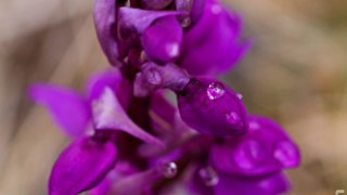
Early Purple Orchid
.flickr-photo { border: solid 2px #000000; } .flickr-yourcomment { } .flickr-frame { text-align: left; padding: 3px; } .flickr-caption { font-size: 0.8em; margin-top: 0px; } Early Purple Orchid, originally uploaded by blather. Early Purple Orchid, Orchis mascula, with a waterdrop on a petal. Taken near Cahercommaun Stone Fort, The Burren, Co. Clare
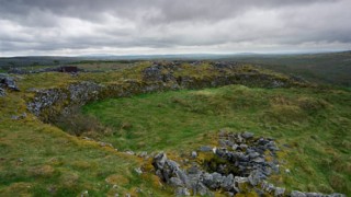
Cahercommaun Stone Cliff Fort, The Burren
.flickr-photo { border: solid 2px #000000; } .flickr-yourcomment { } .flickr-frame { text-align: left; padding: 3px; } .flickr-caption { font-size: 0.8em; margin-top: 0px; } Cahercommaun Stone Cliff Fort, The Burren, originally uploaded by blather. Get High resolution version of this photograph » Perched on a high cliff inland in the Burren, Co. Clare, this early medieval stone fort has an atmosphere all of its own...
The Burren cliffs, Co. Clare, Ireland
Get high resolution photograph » "The Burren (Irish: Boireann, meaning Great rock, Boirinn is the modern form used by the Ordnance Survey) is a unique karst-landscape region in northwest County Clare, in Ireland. The region measures approximately 250 square kilometres and is enclosed roughly within the circle comprised by the villages Ballyvaughan, Kinvara, Tubber, Corofin, Kilfenora and Lisdoonvarna, It is bounded by the Atlantic and Galway Bay on the west and north respectively. Strictly speaking the territory of the Burren or barony of Burren only contains the villages of Lisdoonvarna, Ballyvaughan, Fanore, Craggagh, New Quay/Burrin, Bealaclugga (Bellharbour) and Carron." "The rolling hills of Burren are composed of limestone pavements with crisscrossing cracks known as "grikes", leaving isolated rocks called "clints". The region supports Arctic, Mediterranean and Alpine plants side-by-side, due to the unusual environment. The blue flower of the Spring Gentian, an Alpine plant, is used as a symbol for...
Dry Stone Wall, The Burren, West of Ireland
Get high quality version » Dry Stone Wall, The Burren, West of Ireland
Grikes and Clints of the Burren, Co. Clare, Ireland
Get high resolution version » The Burren: An overview » Wikipedia: The Burren » "The Burren (Irish: Boireann, meaning Great rock, Boirinn is the modern form used by the Ordnance Survey) is a unique karst-landscape region in northwest County Clare, in Ireland. The region measures approximately 250 square kilometres and is enclosed roughly within the circle comprised by the villages Ballyvaughan, Kinvara, Tubber, Corofin, Kilfenora and Lisdoonvarna, It is bounded by the Atlantic and Galway Bay on the west and north respectively. Strictly speaking the territory of the Burren or barony of Burren only contains the villages of Lisdoonvarna, Ballyvaughan, Fanore, Craggagh, New Quay/Burrin, Bealaclugga (Bellharbour) and Carron." "The rolling hills of Burren are composed of limestone pavements with crisscrossing cracks known as "grikes", leaving isolated rocks called "clints". The region supports Arctic, Mediterranean and Alpine plants side-by-side, due to the unusual environment. The blue flower of the Spring Gentian,...


