
The latest in the Blather Neolithic Safari Series…
St. Patrick’s Day. Urgh. Not so much a hangover as just feeling very tired. I’m supposed to be going mountainbiking, but can’t generate the impetus, the motivation. The night before, I’d been out helping David Moore celebrate the launch of his new book, the Accidental Pilgrim, about his cycling trip in pursuit of St. Columbanus. But today, I don’t want extreme exertion, any Irish saints, or bicycles.
But I still want to tramp up the mountains. It’s a beautiful spring day, and I’m damned if I’m going to spend it in a pub. I recruit my housemate, Garrett, and head off across down in the BlatherMobile, eating sandwiches and swearing at parade-goers.
Partly inspired by Tom Fourwinds page about the the Ballyedmonduff Wedge-Tomb, I decide to hunt it down, in the most awkward way possible. Which is rather apt, as it may be one of the most obscurely located national monuments in Ireland. And it’s so very pre-christian, preceding that Jesus lad by about 1700 years.
Instead of driving up the Glencullen road and parking 10 or 15 minutes walk from the site, we park at Ticknock woods, which gives us a good 1.5 hour walk just to find the damn thing.
We park outside the gates at Ticknock, and scoot up the mountainbike trails on foot. It’s warm out, and I end up packing away my jacket. There’s a few downhillers pushing their bikes up hills, and nuclear families out walking labradors, but it’s pretty quiet for a bank holiday – after all, there’s half a million people crowded into the city centre, to watch the parade. We pass the city of communications towers at Three Rock, and branch off from the busier paths and head south towards Glencullen.
It’s then that my faithful left boot suffers a setback. I was wearing them while doing a recent boat course, and the salt water must have gotten to them. We’re only 20 minutes into the hike, and the tongue is hanging off. I cut some cord off my backpack cover, and bind up my foot. Surprisingly, it holds for the entire walk.
Out of over the side of Two Rock, we can see everything from North Dublin round to Howth, Dun Laoghaire and Bray Head, and from The Sugarloaf to Mount Kippure. It’s windier up here, but not cold. the sky dotted with puffs of cumulous clouds. We skirt down the side of the woods down towards Glencullen valley.
Of course, in my braindead state, I’ve forgotten to bring the adjoining OS map, so I can’t use anything south of us for navigation, and left my compass behind too. All I have is one map, and no brain. I make noises about ‘natural navigation’, and pretend I know what I’m doing.
After going off-piste for about 100m, we rejoin the path. Turns out that the trail we were on wasn’t marked on the map… and I had been wondering why the map giving the wrong information about the path that was marked on the map…
We plock our way through some wetland, before rounding the bend, heading eastish. With a little common sense, and by lining up a nearby hill with the old lead mines, we figure out that the tomb must be nearby. All I can see so far is middle-aged men in golfing gear, belting little white balls around a patch of immaculate lawn.
We enter the pine woods. It’s easy going, as the lower branches have been lopped as part of a thinning process. I find a golfball, lob it to Garrett. Our fortune could be made here.
Sunlight and greener foliage appear up ahead. We move towards it, and find ourselves on a forestry access road. Bullseye! 50m across the track, in a clearing, stands our wedge-tomb. Beside it is a doe fallow deer. She’s looking back at us looking at her. I point, alerting Garrett, but she vanishes in a flash. No time for a photo, I have the wrong lense on anyway.
Although it’s in the middle of nowhere in the woods, the tomb is actually a national monument, and comes complete with OPW signage.
Peter Harbison’s Guide to the National and Historic Monuments of Ireland tells us about the site:
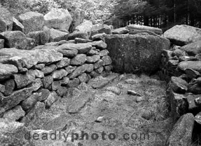
A wedge-shaped neothithic tomb, with a rectangular chamber divided into three unequal parts, and set into a wedge shaped cairn bounded by standing stones, and the whole placed in a double-walled U-shaped setting of large stones. Cremated bone and pottery were found inside. The date of the tomb has been assigned to the early Bronze Age (c. 1700 BC)
On Megalithomania, Tom reckons that until it was excavated (in 1945, I think), the tomb stood much higher. Archeology or ransacking?
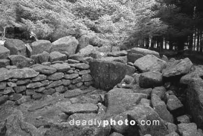
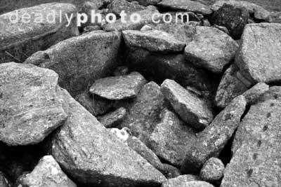
Still though, standing serene in a green clearing, the tomb is an impressive sight.The large chamber features some very neat right-angled stonework – it’s constructed in a perfect rectangle. I wonder how much of this was achieved through ‘reconstruction’? There’s some strange gouges cut into one of the stones dividing the chambers – I’ve included a photograph of them. I assume they’re ancient…
The March sunlight only barely made it into the clearing, and it was difficult to get a good photographic position. I decided to publish the images in black and white, to accentuate the lines of the tomb, and the textures of the stonework…
Finding the Site:
Take the Dundrum Enniskerry Road, turning off in Kiltiernan for Glencullen.
Turn right after Johnny Fox’s Pub, and pass by the entrance to a golf course, on your left. You need to get up through the land here, and onto the gravel access road. The tomb is fairly easy to find – there’s a well marked track into the clearing.
Discovery Map 50: 18 21
Guide to the National and Historic Monuments of Ireland (Amazon.com)
Guide to the National and Historic Monuments of Ireland (Amazon.co.uk)
Megalithomania: Ballyedmondfuff Wedge Tomb »
All images © 2004 Dave Walsh. For usage, please contact us
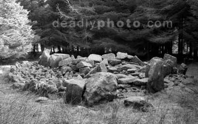
The only decent angle I could get!
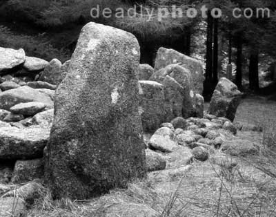
A close up of the standing stones at the West end
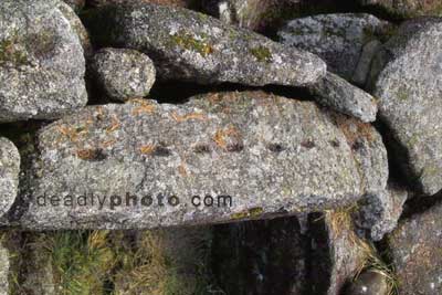
Those strange gouges…
Inside the main chamber
THe main chamber again,
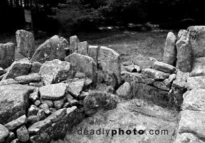
The standing stones, from the within the chamber
The collapsed chamber at the east end
Great article
Great article my ass. A pile o’ Fuggin rocks. Old ones yes. But show me a young rock and I will show
you the exit. They are all old and we walk on the ground of the dead. Bring me some Lyall Watson like illumination on rocks with souls, c’mon fer feck sake.
Maybe, they’re ‘rock books’, like ? Richard Shaver talked about?
The Shaver link is very interesting. I like it though when thease rocks seem to have sentience. There are many examples in very recent history, say five years ago in Iceland where road crews had to dogleg their construction around a certain rock formation because the locals were afraid of
bothering the “hidden folk”. I felt their presence when I visited there, I do not know what it is but it is something.
Found your site from another blog and wanted to see what this was all about
We’re from Glencullen. My Grandad ‘Excavated’ the site. They had no training so it was more like ‘Digging up’ than excavation I’m afraid!
The megalithic tomb Ballyedmonduff (Town of Dark Edmond) is probably one of the best examples of a wedge shaped gallery grave in the country. in excellent state of preservation. i have been there about 3 times and recently found photos from May 1995 when i visited and the trees have grown a hell of a lot since then.
My last visit was early February this year on a very cold, wet saturday afternoon. the place was misty and chilly which probably contributed to the brooding moody atmosphere of the place on the day. all dark coniferous trees and virtual silence except for the sounds of the wood. it’s usually just the setting of a monument like this that can contribute to a feeling of something primeval but not everything.
There’s a book called “If you seek monuments” written by a lady called Kathleen Turner from Rathmichael Historical Society in the early 1980’s which gives information in relation to the monuments of South Dublin/North Wicklow. It’s long out of print but probably it can be got in local Libraries. It has a black and white photo of the Ballyedmonduff tomb in late 1970’s/early 1980’s showing it without trees on a bare mountainside. These megalithic tombs were the resting places of important people and tend to be built on high ground
Eventually Coillte will fell the trees (they’re pretty tall by now)and the tomb will see the light again