
On his hands and knees, Walsh explores the passage tombs of Sligo…
What, in the name of all that is good and questionable, is Sligo County Council playing at?
On approaching the hamlet of Castlebaldwin, there’s a brown ‘official’ sign, announcing that Carrowkeel is 3km to the left. Taking the turn, I find that 500m up the side road, there’s a fork, and another road sign. This one clearly states ‘Carrowkeel 5km’. A kilometre further, and there’s another sign, pointing in a vague direction. ‘Carrowkeel 6km’.
Are the good county councillors on drugs? If not, should they be? Are the people who put up the signs, mad, or blessed with a fine sense of the absurd? Or are the Bricklieve and Curlew mountains home to some weird quantum-bermuda-pentangle-ufo-monster-mystery, where time becomes a loop, or a spiral, or the shape of a punctured Gaelic football?
Or maybe it’s the feckin’ aliens. Some years back, we did have cause to mention these hills, thanks to dubious reports of mysterious plane/UFO crashes and claims of extraterrestrial activity.
Actually, having finally visited this place, I’m not at all surprised that weird stories manifest here. As well as being singularly eerie, Carrowkeel is rated – along with Newgrange, Loughcrew and Carrowmore, as being one of Ireland’s most important megalithic cemeteries.
It was dry, windy day when I visited, and the clouds were grey and uncompromising with a dirty, yellow sunlight leaking along the rough hills. On the rough road towards Carrowkeel, I kept coming out with statements like ‘holy shite’, ‘fuck’s sake’. Out loud, and only me in the car. And some of the time, I wasn’t even referring to the state of the road, or the imminent demise of my car.
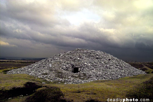
It was the view of dark the cliffs of the Curlew mountains that impressed me, looming above the little red Blathermobile. Each cliff was topped with a pile of grey rocks, each one housing a megalithic passage grave. As the road zigs this way and that, another fold of mountain appears, exposing yet another cairn.
I’m on my own up here, the only one for miles. If I make a mistake, they’ll be weeks finding me. The hills are dark and lonely in the dim half-light, the kind of ancient, stormy atmosphere beloved if film directories (See Lord of the Rings, Reign of Fire, modern takes on King Arthur, etc.). The kind of place where the imagination might run riot. I scan the horizon for any manifestations of The Morrigan.
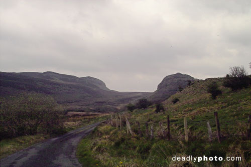
Finally a turn left onto a steep stretch of broken road. At the top, It was straight on for a donkey reserve, or right for Carr… Jesus! This spectacularly spooky valley opened up before me, made even more dramatic by the purple-grey sky and the weird light. I was shooting underexposed dark photos from the car window, still broadcasting my profane awe to the wilds of Sligo. There’s a pile of rocks, (cairn B) perched right at the top of a vertical precipice. How the hell did they get up there?
Up this road – grass in the middle now – to a gate and cattle grid. I open the gate, drive in, and get out to close the gate. An ambush of mountain sheep come screaming out of the hills, bleating furiously. They seem to want a lift, or a toll payment, or maybe their daily heroin fix. I jump in the car, and lock the doors. One can’t be too careful, these ruminants could be on angel dust. Carjacked by sheep? The gardai would never believe me.
One big black-faced mammy nearly has her head in the car window, giving me stick, while another stares at nonchalantly from the middle of the road, her suckling lamb wagging his tail furiously. ‘You sir’, her attitude suggests, ‘are going nowhere till I’m done’.
I outrun the mad sheep, and then run out of road. A sign warns that it’s a rough road from 1000m. I take my chances, and drive up the unsurfaced track, which is a little ‘technical’, but not impossible. A 4×4 would have been useful, and I certainly wouldn’t take any more than one passenger in my current machine. Even on my own, I bottomed out the shocks, driving through one bomb crater.
In between keeping the car between the ditches (and from going over cliffs) I steal glances of Sligo opening up below me, with Lough Arrow to the east. Finally, there’s a small car park, with poles where information signs used to be. An even rougher track goes on ahead, but I have hunch that I’m in the right place.
I open the car door, and the wind starts whipping food wrappers and maps around the interior. I suit up in boots and waterproofs, and sling the camera bag over my shoulder. It’s not raining, but I’m prepared for boggy ground. I head directly up the mountain, away from the road, follow the footprints of others through the heather. Within three or four hundred yards, three cairns appear, G, H and K, great piles of rough stone, looking for all the world like the leftovers of a mining operation. From what I’ve read, the heather and turf is a recent enough addition. When the cairns would have been built, these mountains would have had a similar appearance to the surreal moonscape of the Burren, in Co. Clare.
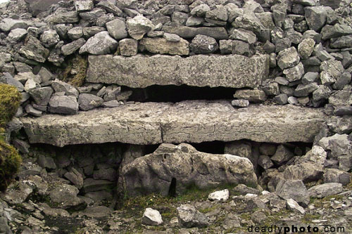
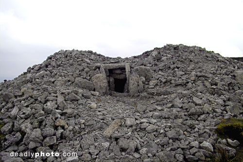
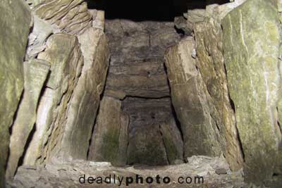
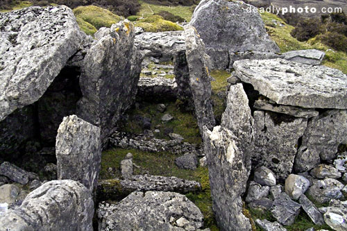
Cairn G is incredibly well-preserved. From the outside, it’s just a pile or rocks with a tunnel. Inside, it contains a complex cruciform chamber, with a layered roof system much like Newgrange (albeit smaller). It’s made of overlapping flat rocks, which have been laid in a spiral helix, to divert water flow away from the polygonal central chamber.
The first man in was Praeger, around 1911, during a rather snappy 12.5 day excavation of the site:
‘In the first (cairn) opened (G) there was an entrance passage, a polygonal central chamber, and three polygonal cells around it, evenly disposed. Several sill-stones divided up the entrance passage, and a sill separated the central chamber from each of the side chambers. Between the sill-stones, each section of the floor was paved with a large slab. The roof was formed of large overlapping slabs, sloping outwards. It was a most symmetrical and beautiful piece of architecture. I had the privilege of being the first to crawl down the entrance-passage, and I did so with no little awe. I lit three candles and stood awhile, to let my eyes accustom themselves to the dim light. There was everything just as the last Bronze Age man had left it, three to four thousand years before. A light brownish dust covered all. The central chamber was empty, but each of the three recesses opening from it contained much burnt bone debris, with flat stones on which bones had evidently been carried in, after the bodies had been cremated in strong fires outside. There beads of stone, bone implements made from Red Deer antlers, and many fragments of much decayed pottery. On little raised recesses in the wall were flat stones on which reposed the calcinated bones of young children. This brief description gives a sample of the construction and contents of the more complete cairns.’
Robert Lloyd Praeger: The Way That I Went, 1937
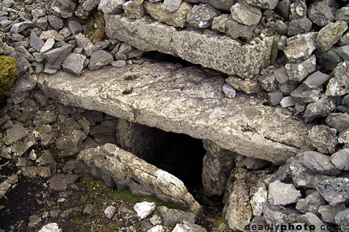
I leave the camera bag and tripod outside, and squeeze past the flat entrance stone, into the narrow entrance tunnel. I let my eyes adjust to the darkness, and breath in the almost dry, still air. The wind is howling outside, but the central chamber – which is high enough to stand up in – is a sanctuary from the elements, constructed from the most incredible arrangement of regular-shaped shaped stones.. I turn, and face the door. Like Newgrange, the cairn has a lightbox above the door, aimed towards the west, presumably to catch the beams of the midsummer solstice sunset. There’s something calming about the place, and I sit there for a while.
As I crawl towards the door, I notice that the entrance stone has a long, wavy slit running straight through it. Maybe it’s how my mind works, but it struck me as a being somewhat vaginal in shape. I’m not sure how this figures in the accepted theories about Carrowkeel, but I’d be interested to find out.
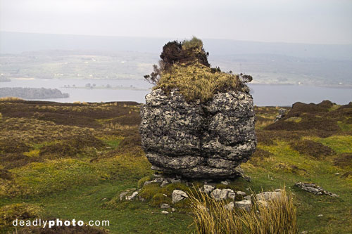
I bring the camera gear inside, but my 28mm lense doesn’t really do justice to the interior. I attempt some shots of the light coming into the chamber. Outside, I notice that there’s a huge slab of rock, sticking out of the south-western side of the cairn (pictured). I wonder if it was used by the cairn builders, perhaps for cremations?.
I climb up towards cairn H, which is too far small to get into. Lacking either a diminutive human or a rope, I just shoot some external photos, taking note of how the top of the cairn strikes me as having a distinctly female form. When a mountain range has a similar outline, they’re usually referred to as ‘the paps’. I blame the Cairn G entrance stone for setting me off on this ‘earth mammy’ tangent. I glance over my shoulder – still not sign of angry triple goddesses.
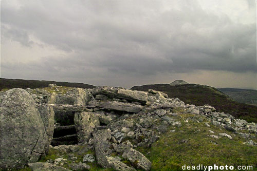
Next, it’s cairn K. Facing north, the entrance looks down onto cairns G and H. The only way to get in is on my hands and knees, and even then it’s a strenuous.. The entrance tunnel is longer and narrower than ‘G’, but the central chamber is huge in comparison. Like ‘G’, ‘K’ has its own peculiar atmosphere. It feels safe, apart from the outside world, without being totally removed.
The next cairn, L, is a write-off. It’s either collapsed, or it was never opened at all. I stand on the top, and survey the countryside. It’s only then that the scale of this megalithic cemetery hits home. Today is too hazy and overcast, but on a clear day, the relationship between Carrowkeel, Knockrea, Carrowmore and the cairns on the Ballygawley mountains can be addressed. In fact, 22km away, at Carrowmore, the Duchas people suppy a panoramic map, showing how the other three sites can been clearly seen. They are not isolated sites.
I’d been thinking of strolling across to cairn E – another passage tomb, and cairn F, a barrow. However, even the Ordinance Survey maps couldn’t prepare me for the series of vertical cliffs between each bunch of cairns. The true distance between each group is quite short, but it’s a good march down some steep paths and knee deep heather to get there. I elect to approach E and F from a different direction. On the way back to the car, I visit the ‘rocking stone’. As Tom on Megalithomania says, ‘this large glacial erratic is wonderfully perched upon a handful of very small stones… I am now not too sure how accidental this 3m tall stone is’. There’s other cairns off to the east, and somewhere below, towards Lough Arrow, there’s remains of a prehistoric village. Whether this is directly connected to the tombs or not seems to be a matter of speculation.
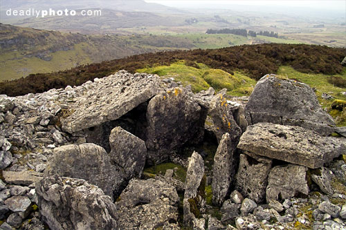
In the car, I roll back down the hill, pulling in again under the cliff the holds cairn E. It’s a stiff scramble up along the cliff to the half-intact tomb. There’s a drop of hundreds of feet to the valley below.
At about 40m long, the barrow is massive, and in several apparently unconnected sections. At the front, the roof is gone, though one of the side chambers still has its’s roof, forming a kind of small square dolmen. Even one of the lintels across the entrance is intact. I squeeze off a few photos, then tramp through the heather to cairn F, which is a disappointment. The biggest passage cairn so far, it’s entirely collapsed. However, its structure was mapped, back in 1911. So it’s back to the car with me, and off with the mucky gear. The little red car bounces down the hill, barely avoiding cliffs and angry sheep. I don’t have time to climb up to cairn B, but I will be back, oh yes.
The area around Carrowkeel is definitely protected, or preserved in some way (I’m unsure of its legal status). However, I’m troubled by the fact that I can just come up here, and tramp around inside a fragile national monument. In a country where some of our heritage has been commodified, it’s odd to come across such an important site that has not been lumbered with an ‘interpretive centre’ or scores of tour buses. This isn’t to detract from the stewardship of other sites, like Newgrange or Carrowmore, each of which has knowledgeable, friendly staff.
On the other hand, would I turn down the chance to sit inside cairns G or K? Would I prefer a barbed wire perimeter fence and guided tours? I’ve been up on this mountaintop alone (excepting the sheep), soaking up the genus loci. Sitting up here, I’m not trying to rationally understand how or why ancient peoples build these monuments. I can do that at home, with stacks of books. Up here, alone, I’m able to ponder on what drew the bronze age Irish to the Curlew Mountains.
While there’s footprints in the mud around the cairns, and well-worn paths, the place seems fairly mildly affected by the passage of modern humans. There’s the odd little bit of litter here and there, and some scrawled graffiti. But the youth of Boyle or Sligo don’t seem interested in lugging crates of beer or flagons of cider to the top of the Curlews. The place seems relatively unharmed.
I bounce down the hills to Castlebaldwin, and make the turn for Sligo town, joining the lines of other cars, hurtling home from their Friday toil.
Links
Official-ish site
Carrowkeel, and astronomy
Megalithomania: Sligo
Nearby Keshcorran Caves
Photos
Note: All photographs © 2004 Dave Walsh. For usage, or to obtain high-rez versions, please contact us
The light was piss poor, and the wind was too strong to keep the tripod steady… so I had to feck around with these a bit…
The eerie valley that greets the traveller. The three highest points are all cairns.
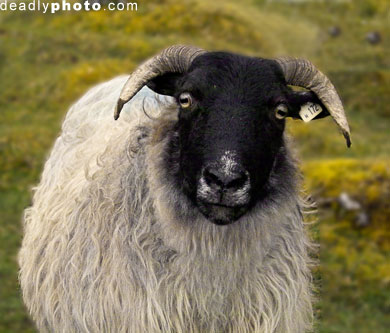
Sheep of DOOM: A curious ruminant tries to hitch a lift
Exterior of Cairn G, with entrance stone
Exterior of Cairn G, with entrance stone
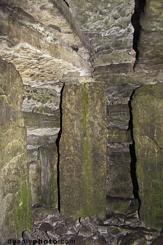
Interior of Cairn G, with support pillars
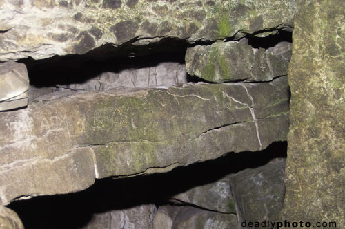
Interior of Cairn G, detail of lintels
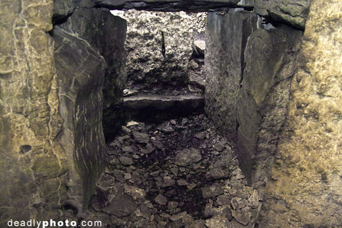
Interior of Cairn G, the view of the entrance from inside, with entrance stone
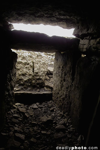
Interior of Cairn G, the view of the entrance and lightbox
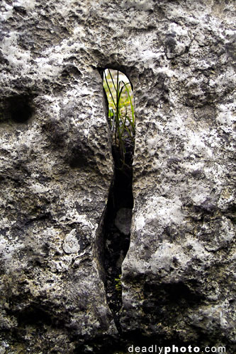
The strange aperture in the Cairn G entrance stone
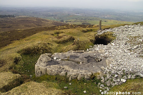
The strange flat rock outside Cairn G
Exterior of Cairn H
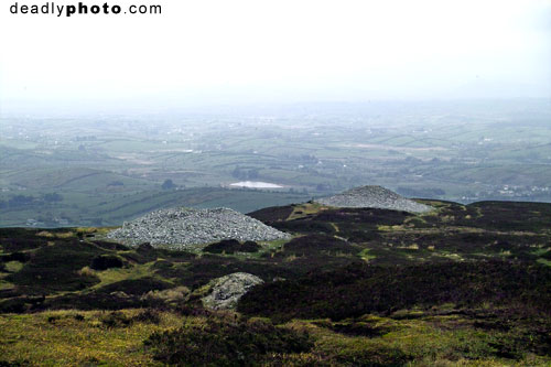
Hazy Day: Cairn G, and H, with south Sligo in the background
Cairn K, exterior
Looking in through the entrance passage, cairn K
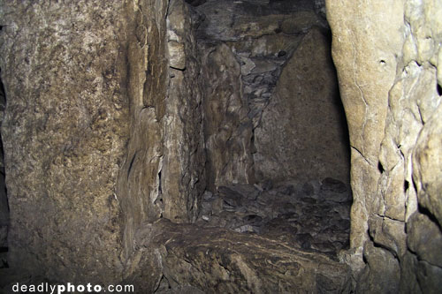
One of the side chambers of cairn K
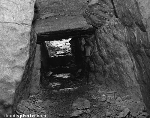
The view from inside of Cairn K… looking out towards the entrance
The ‘Jumping Stone’, with Lough Arrow in the background
A view of Cairns E & F
The remains of Cairn E – a long barrow
The remains of Cairn E – a long barrow – showing the countryside below
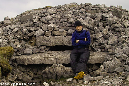
Dave Walsh, Megalith Hunter, pictured beside his latest ‘kill’
Note: All photographs © 2004 Dave Walsh. For usage, or to obtain high-rez versions, please contact us
Was just browsing, wandered into site – I liked the article. I used to live in Sligo at one point – didn’t realise that there were any Megalithic Tombs there.
‘Interior of Cairn G, the view of the entrance and lightbox’ – good photo.
If I had known these were in the environs of Sligo when I was there, I would have taken a look. Great images.
We were just at Carrowkeel last week. We agree the signage is confusing and hysterical as to distance—like you can’t really get there. I think the sign installer confused the order of placement! It was a fantastic view from the top after surviving the drive up!
Thanks you much! We turned right and quit when we ran out of road to support the car. Now we know what we missed! Being 80 & 81 I doubt that we’d have done as well. Thru your description we got close. …May be back?
John & Virginia Kinnaman
We went to Carrowkeel last week -it was a beautiful landscape, but we have not found the tombs. We were very disapointed. Perhaps would we climb to the top of the mountain ? There was no notice and no explanation. This was throughout a very nice walk !
Hi, yes, you need to follow the track right to the top of the mountains!
http://www.megalithomania.com/show/site/984
My wife and I visited site last month (5/07) after viewing your site earlier in year. Somewhat like Newgrange without the crowds. We were caught in halestorm and returned to 1st cairn for shelter. Exciting! Tough road in but followed signs okay.
Recommend visiting before commercialization.